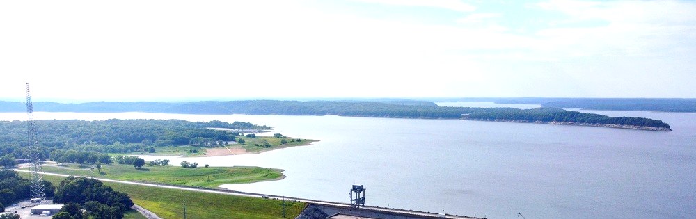
The U.S. Army Corps of Engineers controls Truman Lake's pool elevation the way a farmer manages irrigation — deliberately, seasonally, and for reasons that have nothing to do with your fishing trip. Normal pool sits at 706.0 feet above sea level. By late January, the Corps may have pulled the lake down 5 to 8 feet below that mark. By May, spring rains can push it past 715. The number on that gauge shapes everything: where crappie hold, which boat ramps work, and whether that cove you've been fishing for years is suddenly 6 feet underwater.
Understanding Truman Lake water level before you leave the driveway saves you from a wasted ramp run — or a great trip.
What Normal Pool Actually Means
Truman Lake's normal pool elevation is 706.0 feet above mean sea level (MSL). That's the target the Corps aims for through summer and early fall — roughly June through October — when recreational use peaks and flood-control storage isn't the priority.
At 706.0, the lake's 55,600 surface acres are fully functional. Boat ramps at Harry S Truman State Park near Warsaw, Sparrowfoot Park, Berry Bend, and the Tebo Arm ramps near Osceola are all accessible. Coves are at their mapped depth. Brush piles and timber structure that hold crappie are in their expected positions.
The 706–715 ft band is the sweet spot for fishing and boating. Depths are predictable, fish are where you expect them, and ramps stay open. If you're planning a trip and the gauge is reading anywhere in that window, go.
The Winter Drawdown: Why the Lake Drops Every Year
Starting in late fall — typically November — the Corps intentionally lowers Truman Lake below normal pool. By late winter, the pool often sits 5 to 8 feet below 706.0, putting the gauge in the 698–701 ft range.
This isn't a drought. It's flood-control management. Truman Reservoir was built primarily to protect downstream communities along the Osage River from flooding. Lowering the pool in winter creates storage capacity to absorb spring rainfall before it reaches downstream towns.
For anglers, that drawdown creates real challenges:
- Shallow ramps may be unusable. Concrete ends above the waterline. Several secondary ramps around the Tebo and Sac arms get too skinny for a standard bass boat.
- Fish move to deeper structure. Crappie and bass that held in 6 feet of water over a brush pile are now hanging in 10–12 feet of water over the same pile — because that pile is now partially exposed. Fish compress toward main-channel edges and deep timber.
- Navigation requires more attention. Flats that are 3 feet deep at normal pool become gravel bars at drawdown. If you know the lake, you navigate accordingly. If you're new, go slow and watch the depth finder.
Check current conditions at the USACE Kansas City District water resources page before you trailer a boat in December through March.
Spring Rise: When High Water Complicates Things
Truman's pool typically starts climbing in late February as snowmelt and early rains feed the Osage, Grand, Sac, and Tebo drainages. By April and May, the lake often sits above normal pool — sometimes well above it.
Here's how to read the higher elevation bands:
706–712 ft: Normal to slightly elevated. Most ramps are fine. Fishing stays productive. Crappie move shallower into flooded timber and brush as spawning instinct kicks in.
712–715 ft: Elevated but manageable. Some lower-lying ramps and parking areas flood. Coves push deeper into timber and vegetation. Navigation in coves requires care. Fishing can be excellent if you find fish holding at flooded brush margins.
Above 715 ft: This is where things get disruptive. Many secondary ramps close. The Corps posts closures on their website — check before you go. Flooded timber makes navigation hazardous in unfamiliar coves. That said, experienced local anglers know high water often pushes fish into flooded wood that's normally above the waterline, and it can produce big crappie if you're willing to pick through it carefully.
Above 720 ft: Rare, but it happens in wet springs. At these levels, the Corps may restrict access at some parks. Lakefront structures and low-lying docks can flood. The flood pool ceiling is 739.6 ft — a level reserved for extreme precipitation events — and the Corps manages aggressively to stay well below it.
How Truman Lake Water Level Affects the Crappie Spawn
Truman Lake is one of the premier crappie fisheries in the country — it's hosted Crappie Masters and National Crappie League events for good reason. But the spawn timing shifts with water level, and knowing that pattern makes the difference between a great spring trip and a slow one.
Crappie spawn when water temperatures hit roughly 60–65°F. On Truman, that typically falls late March through mid-May, with Osceola-side coves on the southern Tebo and Sac arms warming first due to shallower water and southern exposure.
Here's how water level shifts the pattern:
- High water delays the spawn. When April rains push the pool above 710–712, cold water from inflowing tributaries keeps cove temps suppressed. Fish stage deeper and longer before moving to spawn. You might be chasing fish in 10–12 feet when you'd normally expect them at 4–6.
- Low water compresses the spawn zone. Below normal pool, fish can't push as far into coves — there's no water there. They spawn on main-body timber and channel edges instead, which makes them harder to target without knowing where to look.
- Normal pool is ideal. At 706–708, crappie move into flooded brush, dock pilings, and standing timber at 3–6 feet. This is the classic Truman spawn pattern that tournament anglers plan around.
For current conditions before your spring crappie trip, check our Truman Lake fishing report. We update it regularly with ramp conditions, water temperature, and what's biting.
How to Check Truman Lake Water Level Before Your Trip
The most reliable source is the USACE Kansas City District. Their water resources page at nwk.usace.army.mil shows current pool elevation at Harry S Truman Dam, updated daily. You're looking for the